News maps allow users to explore coverage of Toronto neighbourhoods
Maps allow readers to compare the perception of how news is covered in their neighbourhood against the reality.
By Ilina Ghosh for the Ryerson Journalism Research Centre
Toronto residents who are concerned about how their neighbourhoods are portrayed in the news can now test their perceptions of news coverage against the reality.
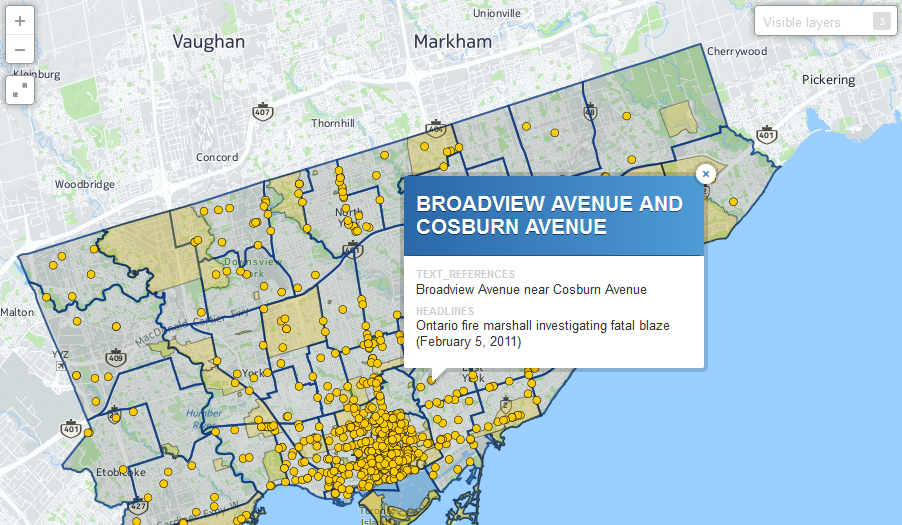
The Local News Research Project at the Ryerson University’s School of Journalism has launched online interactive maps that allow residents in different city wards to explore in detail how their communities are depicted in the news.
“[The maps] allow people to test what their perception of the news is and what the reality is and see if the two coincide,” said April Lindgren, an associate professor in the School of Journalism and the project’s principal researcher. The maps give the public access to data the research project collected on local news reporting by the Toronto Star and the user-driven local news website OpenFile.ca.
Residents can use the maps to get an overall sense of where news in the city is—and isn’t—covered; compare patterns of local news coverage by two different news organizations; examine the geographic patterns of reporting on crime, entertainment and other major news topics; and find out what kind of news is covered in each of the city’s wards.
“The patterns are interesting because they show a lot of coverage of the downtown neighbourhoods and central Toronto and as you go away from the centre of the city, you see less and less reporting overall in more far-flung neighbourhoods…This suggests there might be lots of opportunities to do stories in those other areas outside of the core,” Lindgren said.
Continue reading this story on the Ryerson Journalism Research Centre website.
H.G. Watson was J-Source's managing editor from 2015 to 2018. She is a journalist based in Toronto. You can learn more about her at hgwatson.com.